

(main menu)
CAMPBELL
articles
SITEMAP
site is
ABOUT
NEW

|
|
(main menu) |
CAMPBELL articles |
|
SITEMAP |
site is ABOUT |
NEW |
|
The young Rowland Hill was almost unbelievably precocious.2 He made his first working watermill at the age of five and was teaching at his father's school by the time he was eleven. He was carpenter, locksmith and clockmaker; he wrote a play; he improved his father's public demonstrations of electricity. It is perhaps hardly surprising that someone with so enquiring a mind and so great a relish for practical difficulties should have been chosen by his teacher to construct the maps for a school atlas. He was then sixteen. Despite the problems, he was able to dash off a map of Spain and Portugal, which was apparently published. 3
At one point Hill built a flat-bottomed boat, meaning to sail up the Birmingham and Worcester Canal to the Severn and hence to his uncle at Shrewsbury. Unfortunately, this scheme was a little premature as the canal was barely half built. No doubt inspired by his craft's performance on the local pond, he later taught navigation to a midshipman, an interesting variation on the 'coals to Newcastle' theme.
With this track record, it was almost inevitable that the indefatigable Hill would turn to land surveying. Unable to find a suitable book or mentor, he taught himself. Mapping the playground of his father's school soon palled. In 1819, having read Mudge's account of the Ordnance Survey's trigonometrical survey, and 'finding it more interesting than any novel', he proceeded to survey Birmingham, rousing his class for the purpose before three in the morning on three successive days.4 His diary does not record their reactions .
Two years previously in 1817, when he was twenty-two, he made his only commercial1y successful foray into cartography. A murder had taken place near his school, at Erdington a few miles north-east of Birmingham. The circumstances had produced much newspaper coverage but no adequate map to inform the public of the all-important topographical context.
Killing, as it were, two birds with one stone, Hill took his class to the spot, measured all the features that had been mentioned in the trial and produced his 'Map of the roads, near to the spot where Mary Ashford was Murdered'. The bald facts of the case were these. Mary Ashford had gone dancing on the evening of 26 May at the ominously named Tyburn House (right of centre on Hill's map). There she met the accused, one Thornton. Her battered body was discovered, a few hours after her return with Thornton, at 6.30 the following morning in the 'fatal pit' (i.e. pond - subject of the vignette and the smaller detail).
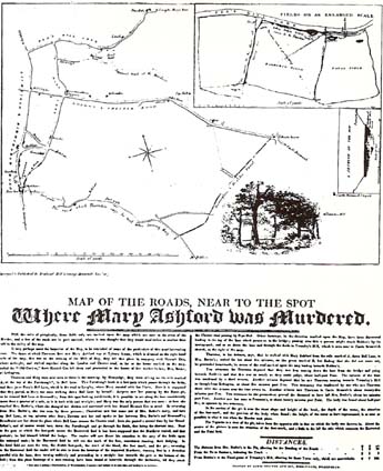 | Courtesy of the British Library |
Using an enlargement (upper right) of the 'harrowed' and 'fatal' fields, which appear towards the top left of the main map, Hill traced the movements of Ashford and Thornton. In the ensuing trial, Thornton was acquitted because of an alibi which had him following a route due south instead of the south-easterly direction indicated by the murderer's 'supposed track'. Hill's map - co-published with George Morecroft, 'a former schoolfellow, to whom, though he was much older than myself, I was then giving private lessons in surveying' - and more particularly its accompanying text (unfortunately too dense to reproduce here) examine the topographical evidence in some detail.
The map was published six months after the event, at a time when public interest was restimulated by an impending appeal. Despite the verdict, Thornton was found guilty by local opinion and a subscription was raised to revive the long-disused right of appeal against acquittal. The case broke further new legal ground when Thornton in his turn dusted off an ancient procedure and challenged the King's Bench judges to armed combat. Since they could not respond, the result was a victory for Thornton, followed by an Act abolishing both wager of battle and appeal against acquittal.
Hill and his partner cleared £15 in what may prove to have been the first exercise in forensic cartography. When he discovered that another publisher had made an unauthorised copy of his amateur effort he might have been flattered.5 In fact he was 'incensed at such rascally treatment' and was about to sue when he realised that he had failed to note the exact day of publication (required by the 'Hogarth' Copyright Act). Instead, he 'immediately had the plate altered before any more impressions were taken'. The British Library example, acquired for George III's collection, is of Hill's first state, with the date expressed loosely as 'Nov 1817'. It can be seen in the 'What use is a map?' exhibition, on display (free) in the British Library's Map Gallery in the British Museum building until the end of 1990 {catalogue entry no.52}.
References:
1. Hill is not referred to in R.V. Tooley, Tooley's dictionary of mapmakers (Tring: Map Collector Publications, 1979), nor
in its Supplement (1985).
2. George B. Hill, The life of Sir Rowland Hill KCB...and the history of Penny Postage, 2 vols (London, 1880), I, 44-99.
3. Does any reader know of the whereabouts of an example?
4. If this Birmingham plan was published it is certainly rare today. It is not listed in: City of Birmingham, Public Libraries,
Reference Department, A catalogue of the Birmingham Collection (Birmingham, 1918), pp.598-611. Also Supplement
(Birmingham, 1931), pp.562-75.
5. No further details are available about this piracy. Again, can any reader identify an example?